|
Background
|
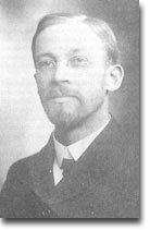
The chair of the Geography Department of Michigan State Normal College in Ypsilanti, Michigan, from 1901 through 1939, Mark Jefferson was known for his mentorship of several famous geographers, such as Isaiah Bowman and Charles C. Colby. His varied interests ranged from astronomy and river meanders to South American geography and the distribution of the world's population. In addition to teaching summer courses at Harvard University, Jefferson also served as Chief Cartographer for the American Peace Commission at the postwar negotiations in Paris in 1918-19.
|
|
Innovation
|
During the early twentieth century, with social Darwinism still very much in vogue, sociologists were interested in defining what differentiated "civilized" people from rest of humanity. Geographers jumped on the bandwagon by attempting to map the exact extent of the "civilized" world. But how could this be done?
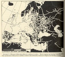
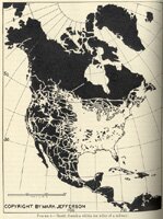
In 1928, Mark Jefferson attacked this problem by mapping the buffer zones around the world’s railroads. At that time, railroads were synonymous with progress, having been instrumental in opening the Western United States and in developing a modern economy of scale. A "buffer zone" is the extent of area around a geographic element that is influenced by it in some manner. The concept of a buffer zone had been understood for years; the U.S. Railroad Act of 1862 doled out parcels of land to railroads for miles on either side of the line based upon this understanding. Jefferson used buffer zones to create a more spaitally precise understanding of culture realm. In his article, "Civilizing Rails," Jefferson started on the assumption that the construction of a railroad was evidence of advanced "civilization." Next, he drew all of the world’s railroads on a series of continental maps. On either side of each railroad he drew a white-colored buffer zone arbitrarily set at ten miles. Those parts of the world, such as Western Europe and the Eastern United States, which had the most thorough network of railroads, appeared almost a solid white, meaning that few if any areas were more than ten miles from a railroad. Jefferson called these areas "railwebs." These places were consistent with what was considered the most "civilized" parts of the world.
Other places on the globe had varying degrees of "civilized" influence based upon the amount of buffer space compared with the darker areas in between. Parts of Western Russia and the Western United States had a large network of railroads, but significant gaps in between. These areas were called "railnets," continuing the foreshadowing of the Internet jargon of the late twentieth century. Other places, such as much of South America, Africa, and Asia, were almost completely devoid of railwebs or railnets, with the exception of the occasional railroad linking colonial outposts.
The use of buffer zones in spatial analysis is still going strong today, although without Jefferson's emphasis on determining cultural supremacy. Modern GIS systems incorporate "catchment areas" when looking at the economic impact of a given business or urban area on an overall geographic region. Environmental specialists use "zones of impact" when determining the consequences of development and habitat loss in sensitive wildlife areas.
|
|
Publications
|
"Geographic Distribution of Inventiveness." Geographical Review Vol. XIX (1929): 649-661.
Peopling the Argentine Pampa. New York: American Geographical Society, 1926.
Man In Europe. Ypsilanti: 1924.
"Some considerations on the geographical provinces of the United States." Annals of the Association of American Geographers, Vol. 7. (1917), pp. 3-15.
|